Scientists Are Rushing to Find America’s Secret Wetlands
5 min read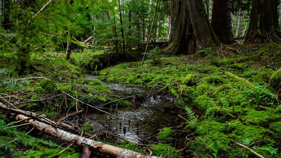
This article was originally published by High Country News.
On a warm day in August, Anthony Stewart hiked through a forest on Washington’s Olympic Peninsula, making his way through a tangle of ferns and grasses. Wispy, lichen-coated branches hung overhead, providing shade as he set down his backpack and shovel, and he and his team prepared to dig.
This was one of Stewart’s favorite study sites, he says. It’s relatively dry on the surface, but just underneath it, a layer of reddish soil, full of organic matter, gives way to gray-blue, claylike soil. These layers, formed over time as water flooded the area, are signs of a wetland. But like many forested wetlands in the Pacific Northwest, this area doesn’t appear on any state maps.
In a study published in Nature Communications this past January, Stewart, a Ph.D. student at the University of Washington’s School of Environmental and Forest Sciences, and his team reported the surprising abundance of unmapped, carbon-rich wetlands in the Pacific Northwest’s forests. The scientists studied the Hoh River watershed, which snakes westward across the Olympic Peninsula, documenting potential wetlands that, because of the thick forest canopy, were invisible to satellite imaging. Including them in estimates of the watershed’s carbon-storage capacity increased them by fivefold.
Conserving forested wetlands not only protects valuable habitat; it could help stabilize the climate. But first, the wetlands must be put on the map—and that is no easy task.
Wetland ecosystems are stunningly effective at soaking up carbon from the atmosphere. Despite covering only less than 10 percent of the world’s land surface, they contain roughly 20 to 30 percent of the carbon stored in the soil. And because the plant matter in the waterlogged soil decays slowly, their carbon tends to stay put.
Wetlands provide other benefits too: Some 40 percent of all animal and plant species rely on wetlands. The gnarled roots of wetland trees and plants purify water, and the wetland soils absorb it, providing flood protection to nearby areas.
Since the 1920s, the U.S. Department of Agriculture has surveyed the types and quality of soil throughout the nation. But until recently, these soil maps focused primarily on agricultural land, leaving out most forests and thus huge gaps in knowledge about the Pacific Northwest and Alaska. On top of that, “wetlands were not at all a focus in forested landscapes,” says David D’Amore, a soil scientist with the USDA Forest Service and a co-author of the study.
To identify these hidden forested wetlands and estimate their carbon content, the researchers used the Wetland Intrinsic Potential (WIP) tool, a wetland-mapping tool that uses LiDAR, or Light Detection and Ranging, an aerial remote-sensing technique that can resolve details underneath the tree canopy. The researchers then randomly selected 36 sampling sites across the entire Hoh River watershed, many of which were far from any sort of trail. Armed with shovels, hoses, and pumps, the researchers drove along bumpy backcountry roads and bushwhacked their way through thick woods. Once they arrived at their sampling locations, they used shovels to dig three-foot-deep holes in the ground. “It’s really intensive to get a carbon measurement,” Stewart says. “It’s not an easy path.”
The team scooped the soil into gallon-size plastic bags and carried it back to the University of Washington. In the laboratory, Stewart ground the samples to a fine powder and heated them to 1,000 degrees Celsius (about 1,800 degrees Fahrenheit). At that temperature, the carbon-containing substances in the soil were completely decomposed and transformed into carbon dioxide, allowing the scientists to measure its carbon content. Finally, the researchers combined the soil-carbon data with remote-sensing topography information to create a model of the amount of soil carbon that is stored across the watershed. “We just rediscovered these really carbon-rich forested wetland areas that weren’t being mapped by the currently available land data sets,” Stewart says.
In the 2016 National Wetland Condition Assessment, a federal survey of the nation’s wetlands, Amanda Nahlik, an ecologist and biogeochemist in the Office of Research and Development at the Environmental Protection Agency, concluded that wetlands in the West held about 6 percent of the total carbon stored by wetlands in the Lower 48. “We recognized we were probably underestimating the amount of carbon stored in the West,” she says. Stewart’s study confirmed this hunch. “There is this landscape that’s uncharacterized that we need to start to target,” Stewart says.
In general, wetlands aren’t faring well. Half of the wetlands in the Lower 48 have disappeared since the 1780s, and, over the past decade, the rate of wetland loss has doubled, according to the Fish and Wildlife Service’s most recent National Wetlands Inventory. Roughly half of the wetlands in the Mountain West are in poor condition. Though there are thought to be fewer wetlands in the arid West than on the East Coast, “that does not mean that those wetlands are less important,” says Megan Lang, the inventory’s chief scientist. “In fact, it might mean that those wetlands are more important, because there are fewer of them.”
The two main drivers of wetland loss in the West, Lang says, are drought and cattle grazing. Climate change, which is expected to increase aridity in the West, could dry up huge portions of the region’s remaining wetlands by 2050. And when wetlands are destroyed, their carbon is often released into the atmosphere, further worsening global warming.
Last year’s U.S. Supreme Court decision in Sackett v. Environmental Protection Agency changed the federal definition of a wetland under the Clean Water Act, disqualifying thousands of miles of ephemeral streams and millions of acres of wetlands—including those along the Hoh River—from protection under that law. Some federal and state initiatives are attempting to compensate: Late last month, President Joe Biden announced a goal to protect 8 million acres of wetlands over the next six years. And earlier this month, Colorado became the first state to pass legislation protecting the wetlands excluded by last year’s Supreme Court decision.
Lang emphasizes that it’s crucial to map, measure, and conserve the wetlands we still have: “If we’re going to maintain resilience to climate change, if we are going to have clean water for the future, if we’re going to keep feeding our families, if we are going to be safe from flooding, we are going to need to do better in terms of wetland conservation.”


